- Home ›
- County map of Ireland
County map of Ireland
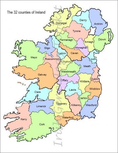
The county map of Ireland below shows all 32 historical Irish counties across the island. It makes no distinction between the Republic of Ireland and Northern Ireland. See below for lists of the respective counties for each area.
You can download a full-page version, free, via the link in the Where Next? section further down the page.
The names of the counties are those in modern use. And they are referred to individually with the word 'county' coming before the name, not after.
So, if your ancestors came from Clare, they would have said they came from County Clare, not from Clare County.
The only exceptions were 'King's County' and 'Queen's County' which have now reverted to their former names of County Offaly and County Laois respectively.
You'll find historical and other pertinent general information about the counties of Ireland below.
Alphabetical list of the counties of Ireland
The six counties of Northern Ireland (UK) are Antrim, Armagh, LondonDerry, Down, Fermanagh and Tyrone.
The 26 counties of the Republic of Ireland are Carlow, Cavan, Clare, Cork, Donegal, Dublin, Galway, Kerry, Kildare, Kilkenny, Laois, Leitrim, Limerick, Longford, Louth, Mayo, Meath, Monaghan, Offaly, Roscommon, Sligo, Tipperary, Waterford, Westmeath, Wexford and Wicklow.
You can also find out more about each of the historical counties on the pages below, which are arranged alphabetically:
These pages provide a little extra social and historical information about each of the counties.
Irish counties: Historical background
As you familiarise yourself with the county map of Ireland and start to use it in your genealogy research, you may find the following information useful:
The counties of Ireland were created between the late 12th century, when the Anglo Normans invaded, and the early 17th century, and tend to follow the ancient lines drawn between powerful clan families.
Dublin was the first county to be set up with a sheriff empowered with legal, military and administrative controls. From that point, the process of creating the counties of Ireland spread out mainly eastwards and did not reach the north until the early 1600s.
Antrim and Down were the first Ulster counties created, with the rest remaining 'un-shired' until about 1585.
It was Wicklow, however, that in 1606 became the very last of the counties of Ireland to be formed.
Some of the names of the counties of Ireland have changed over the years. You may well encounter these alternative names when you are looking at historical and genealogical documents.
You may come across:
- Caterlaugh or Caterlagh, rather than County Carlow, on medieval maps
- County Coleraine, which became County Derry, which is also known as County Londonderry (the names are interchangeable)
- Queen's County (not County Queens), which is now County Laois and sometimes written as Leix, and
- King's County (not County Kings), which is now County Offaly.
There also used to be the counties of Nether Tyrone and Upper Tyrone which were merged to become simply County Tyrone, and, until 1606, the county of Desmond which was shared between Cork and Kerry.
Where next?
- Not sure where/when your Irish ancestors lived? Find out how to start tracing your Irish Roots.


